Apollo 15 landed on the Moon fifty years ago today, on July 30, 1971. While Apollo 15 was the fourth mission to land a crew successfully on the lunar surface, it still pioneered many new technologies and had many firsts.
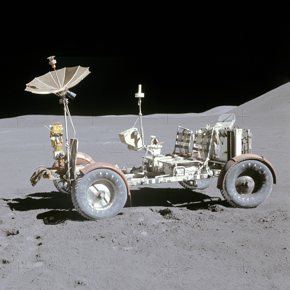
Some of the technologies developed for Apollo 15 included new suits, which were more flexible and had longer life support capabilities, as well as the Lunar Roving Vehicle (LRV), a rover capable of speeds up to 15 km / hour. With these advancements, astronauts Commander David (Dave) Scott and Lunar Module Pilot James (Jim) Irwin were able to travel more than eight times the distance traveled during the previous mission, for a total of over 25 km.
This distance was accomplished over the course of three EVAs, totalling 18 hours and 13 minutes (from hatch open to hatch close on each EVA). During this time the crew explored the Hadley-Apennine region, which included Hadley Rille, a large channel carved out by lava flows. They also tested the new equipment and set up lunar surface scientific experiments. Check out this amazing Apollo 15 50th Anniversary video from the LROC team!
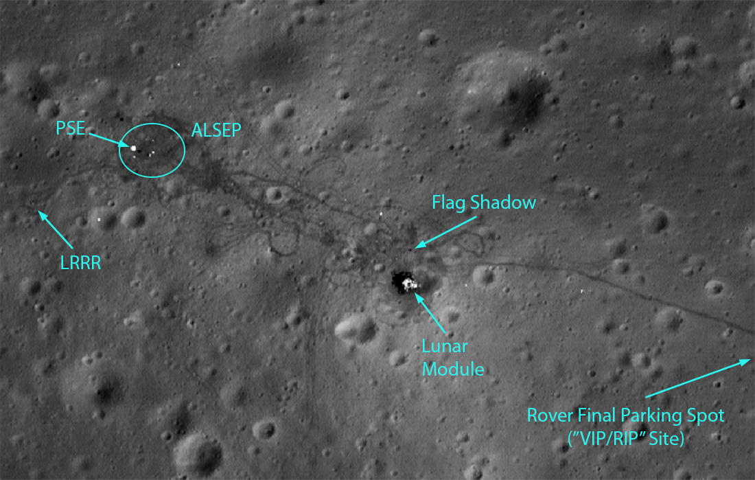
The first EVA took six hours and 28 minutes to complete and covered a distance of about 9 km. During the traverse, the astronauts made three major stops to collect geologic samples on Hadley Delta and to set up the various instruments. Their first objective was to pinpoint the location of their landing spot, so they drove toward the rille until they could see Elbow Crater, named because it was located at a bend in the rille. In addition to its geologic value, this known location let them calculate the exact location of the LM using the rover's navigation system. While on Hadley Delta they collected samples at Stations 1 and 2, then headed back to the LM to drop off the samples and set up the Apollo Lunar Surface Experiments Package (ALSEP), a set of 7 scientific instruments. On the way back, Scott noticed a vesicular basalt (a dark-colored volcanic rock with small air bubbles in it) and the two astronauts faked an issue with a seatbelt so they could stop and quickly collect the rock, which led to it being called the Seatbelt Basalt.
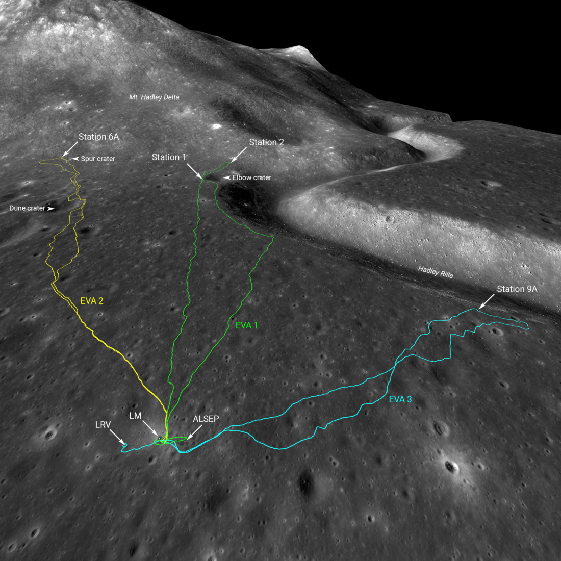
On the second day the astronauts headed back south to the Hadley Delta for EVA 2. This time, they travelled southeast, away from the rille. EVA-2 covered 11.7 km and lasted 7 hours and 1 minute. The astronauts stopped at a total of four stations and collected numerous rocks and other geologic samples. One of these was sample #15415; known as the Genesis Rock, it became one of the most significant samples collected at Apollo 15. The Genesis Rock is made of anorthosite (a light-colored rock that is almost pure plagioclase and makes up the lunar highlands) and was at first believed to be part of the Moon’s primordial crust. Scientists later discovered that, while still very old (at least 4.1 billion years), it was younger than the formation of the Moon's crust.
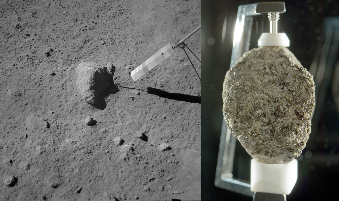
The third and final EVA covered a distance of 4.3 km over the course of 4 hours and 44 minutes. The EVA began on the third day with the retrieval of the drill core sample from the ALSEP. This core was 2.4 m long — 2 meters longer than previous lunar core samples. After successfully collecting the core, they continued with the EVA. Unlike EVA-1 and EVA-2, which explored terrain south of the landing site, EVA-3 extended west towards Hadley Rille, north of the section of the rille which had been explored in EVA-1. At the first stop at the rille, they collected a sample known as “Great Scott,” a 9.6 kg boulder which is one of the largest samples brought back from the Moon. The Moon rock at LROC is a piece of the Great Scott sample!
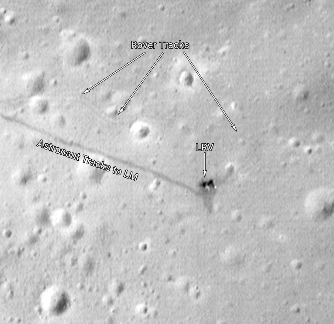
After exploring Hadley Rille, the rover headed eastward, back towards the lunar module. Here, the astronauts recreated the Galileo gravity experiment (which demonstrated that objects of different mass fall at the same rate) by dropping a hammer and a feather at the same time. In the vacuum-like conditions of the Moon, the feather and hammer hit the ground at the same time. Finally, Scott drove the rover past the lunar module and parked at a site approximately 160 m east of the LM. This site, known as the “VIP site,” was the rover’s final parking place (so called for the rover's VIP seat to the LM liftoff; it was alternatively called the "RIP site"). You can still see the rover at this location in present-day images from LROC!
Members of the LROC team documented the astronaut activities on a minute-by-minute (and sometimes second-by-second) basis to bring this historic event to life. We've carefully mapped the three EVAs based on Apollo 15 transcripts, photographs, and video, as well as rover paths digitized from Dr. Phil Stooke’s thorough mapping of the rover traverses. You can explore these temporal traverse maps, which show the astronauts and the rover on a NAC basemap as they progress through each EVA, across all the stations where they stopped to collect samples, take photographs, and set up experiment hardware. Don’t forget to view the Apollo 15 landing site in 3D using Lunar QuickMap!
Check out the other temporal traverses here:
Apollo 11
Apollo 12
Apollo 14
Read more about Apollo 15 in these related posts:
Retracing the Steps of Apollo 15: Constellation Region of Interest
The Apollo 15 Lunar Laser Ranging Retroreflector - A Fundamental Point on the Moon!
Layers near Apollo 15 landing site
Hadley Rille and the Mountains of the Moon
The Original Interplanetary Mountaineers
Soaring Over Mighty Mt. Hadley
Follow the Tracks
Published by Madeleine Manheim on 30 July 2021