The Surveyor spacecraft were designed to characterize lunar surface properties to help engineers design the systems astronauts would use exploring the Moon. Seven Surveyors were launched to the Moon and five succeeded in landing and returning useful data. Surveyor 1 landed in May 1966 and Surveyor 7, the final mission in the series, landed in January 1968.
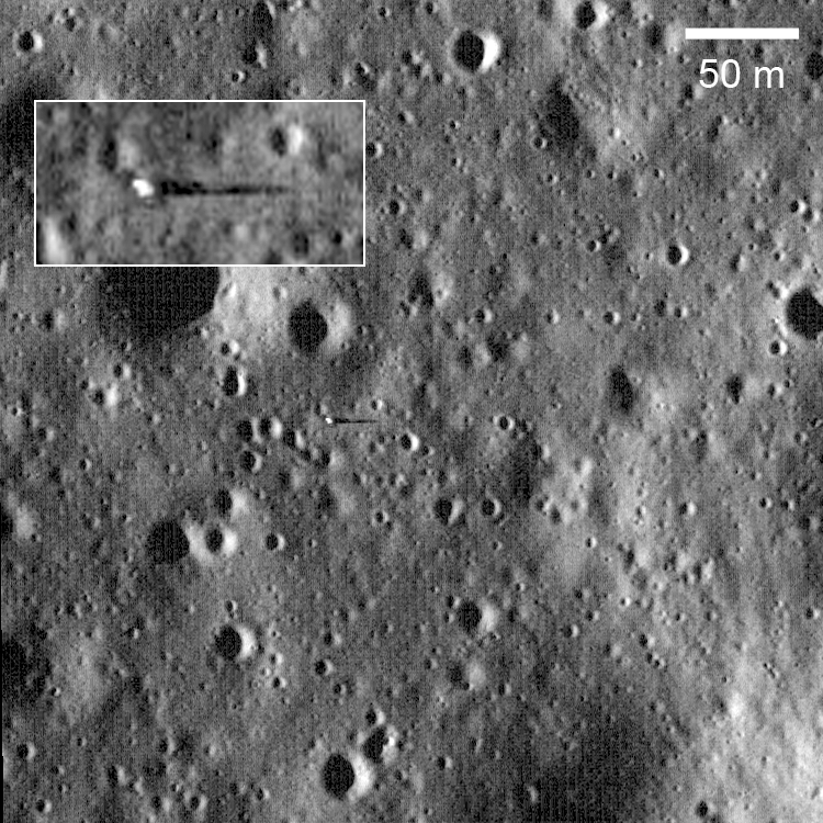
Surveyor 6 Landed 10 November 1967 in Sinus Medii (0.5°N latitude, 358.6°E longitude), almost dead center on the front side of the Moon. One of its key experiments was measuring the surface chemistry with an alpha scattering detector, which showed the landing area to be basalt, similar to the surface measured by Surveyor 5. Surveyor 6 completed the data acquisition that the Apollo program needed and thus allowed Surveyor 7 to be sent to a site that was of higher scientific interest.
The Surveyor 6 spacecraft survived the two week lunar night, but no significant data were returned after contact was reestablished on December 14, 1967.


Near the end of the nominal two week mission NASA engineers commanded the Surveyor 6 engine to fire for a few seconds. The spacecraft rose about 4 m above the surface and landed about 2.5 m from its original landing spot. This was the first successful liftoff from the lunar surface. And perhaps the only spacecraft to land twice on the Moon.
Browse a map projected version of the NAC image and find Surveyor 6 for yourself!
A quick note on lighting conditions. Due to the Moon's slow rotation, the solar incidence angle is always changing at a a given site as LRO passes over. With time LROC can image a feature under varying lighting (from dawn to noon to dusk) thus providing a powerful tool for confidently identifying small features, such as the Surveyors, and fully understanding the subtleties of the local geology.

Images taken towards noon emphasize subtle differences in albedo (apparent reflectance or brightness) while images taken with the Sun low to the horizon bring out topography. From the high Sun images we see at all landing sites (Apollo, Surveyor, Luna) that the blast from the descent engines locally changed the surface albedo to varying degrees. This effect is mostly likely due to the engine plume rearranging dust particles of different sizes. The magnitude of the effect may be different in the highlands vs the mare.
LROC Image of Surveyor 1.
LROC Image of Surveyor 3 and Apollo 12.
LROC Image of Surveyor 5.
Published by Mark Robinson on 21 March 2010