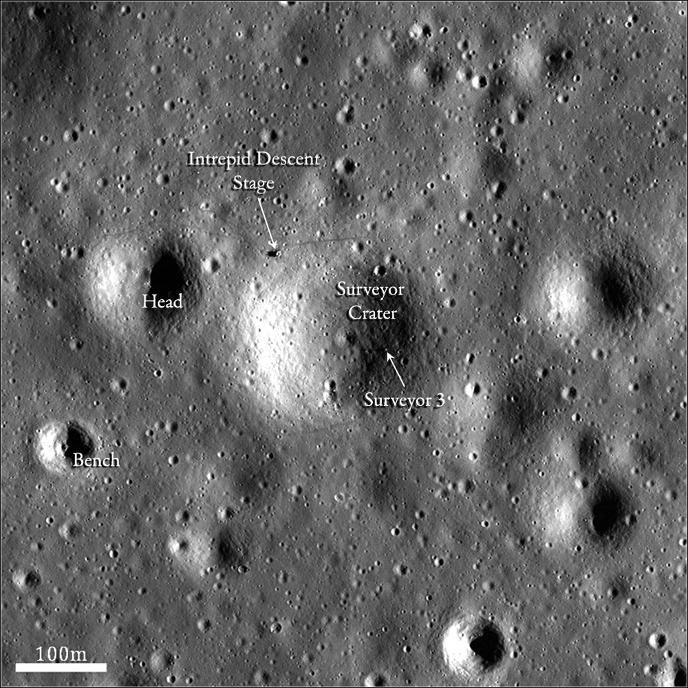
The Lunar Orbiter program, much like LRO, was designed primarily to obtain images to allow scientists and engineers to characterize the lunar surface in the context of finding safe and engaging landing sites for future missions. A total of 5 Lunar Orbiters (LO) were sent to the Moon, and they collectively photographed most of the lunar surface at 60 to 600 meters resolution, with resolutions as high as 1 meter per pixel for some of the LO-5 photographs. In 1967, NASA launched Lunar Orbiter 3 (LO-3) with the primary objective of finding safe landing sites for the Surveyor and Apollo missions. Both a Surveyor and an Apollo mission soon visited one area that the Lunar Orbiter photographed. Surveyor 3 landed on April 20, 1967 in Oceanus Procellarum at approximately 3.02°S and 23.42°W. The spacecraft landed in a small, 200 m crater that was later named Surveyor Crater.

Two and a half years later, on 19 November 1969, Apollo 12 demonstrated the Lunar Module's capability to make a pinpoint landing by setting down on the edge of Surveyor Crater, about 155 m from the deactivated Surveyor 3 spacecraft. Almost 45 years later, LROC imaged the same area of Oceanus Procellarum that LO-3 photographed. The LROC image, however, reveals some new features - the Apollo 12 Lunar Module (LM), Surveyor 3 spacecraft, and astronaut tracks are all visible. Perhaps most evident is that Surveyor Crater and the area around the LM are noticeably brighter than in the LO image.

This increase in reflectivity resulted from effects of the rocket exhaust interacting with the regolith during the descent of the Apollo 12 Lunar Module. Directly beneath and adjacent to the LM the surface appears darker because the exhaust gas disrupted and roughed up the surface. However, a few meters away from the lander and extending outward for several hundred meters, the surface was altered in such a way as to make it more reflective, possibly a result of smoothing. The Apollo 12 descent experienced greater thrust and therefore greater soil erosion rates than Apollo 11. During the Apollo 12 descent, Pete Conrad flew the spacecraft around the edge of Surveyor Crater in order to get to the safe landing spot he wanted. The crater then likely acted as a mechanism to contain the rocket exhaust, causing the entire crater to experience disturbance and appear more reflective.

Be sure to explore the entire NAC frame (M177785917L and M177785917R mosaic)!
For more information on the Apollo 12 and Surveyor 3 landings, check out these previous LROC Featured Images:
First Look: Apollo 12 and Surveyor 3
Apollo 12 Second Look: Midday on the Ocean of Storms
Pinpoint Landing on the Ocean of Storms
Published by Ryan Watkins on 9 July 2013