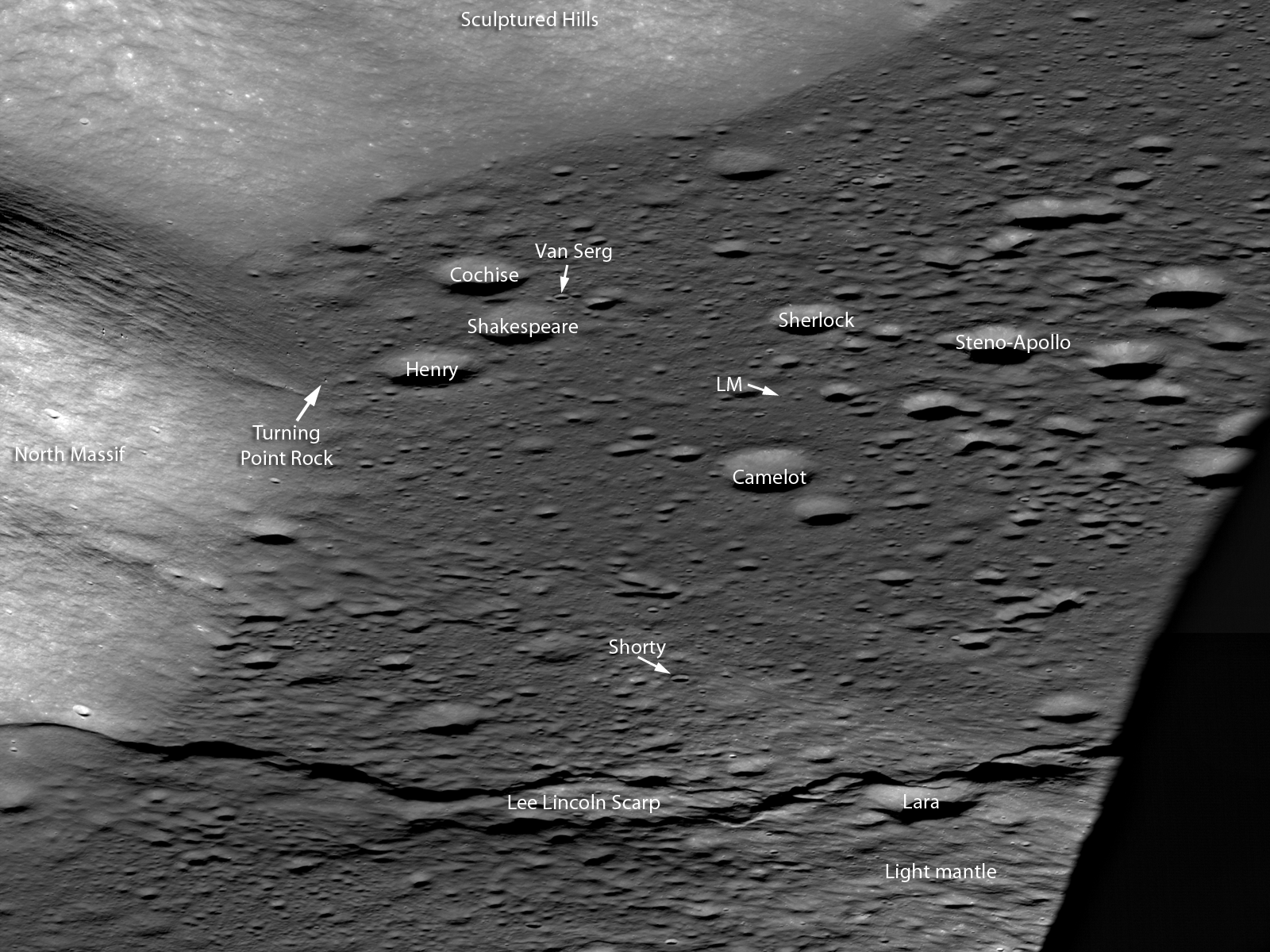
In the lower right, South Massif casts a long evening shadow across the mare basalt flooded Taurus Littrow valley. Note the sharp boundary of the flat mare against the slopes of the Sculptured Hills in the background, similar to a lake shoreline, revealing the very fluid nature of the lava when it filled the valley. Your eye is drawn to the sharp line snaking across the bottom of the image. Note how this ridge traverses across the valley floor and up onto the lower slopes of North Massif (lower left). Astonishingly this feature is a large, young fault: imagine the ground in the foreground being pushed to the east and the crust buckling, a whole section was pushed up and onto the back side of the fault (low angle thrust fault). This step in the valley floor was the result of large scale contractional forces pushing the crust together. The landform created by this type of thrust fault is called a lobate scarp, this one is named the Lee Lincoln scarp. The Lee Lincoln scarp has the distinction of being the first and only extraterrestrial fault to be explored by humans. Astronauts Harrison Schmitt and Gene Cernan actually drove the Lunar Roving Vehicle (LRV) up and over this ridge during their three day exploration of the valley.
Where the Lee Lincoln scarp stretches into the highlands of North Massif, it abruptly changes directions and extends along slope far beyond the Apollo 17 landing site (black arrows on full NAC image below). The Lee Lincoln scarp is one of a number of such tectonic landforms that were only found in the high resolution Apollo Panoramic Camera images that covered part of the lunar equatorial zone. In LROC NAC high resolution images, lobate scarps have been discovered across the Moon at all latitudes (Watters and coworkers, 2010). The pristine appearance of the lobate scarps and the fact that the features cut across young, small-diameter craters are evidence that the scarps formed recently, more recently than the young craters they deform. The globally distributed population of lobate scarps is an indication that contractional forces are acting on the lunar crust as a result of slow cooling and shrinking of the still hot interior of the Moon.
It was forty years ago today that the Apollo 17 crew splashed down in the Pacific Ocean, ending our first period of human exploration of the Moon. The extensive measurements beamed back from LRO every day are setting the stage for the next era in robotic and human exploration of the Moon. Where would you go on the Moon to continue the work of the Apollo crews?
Trace the Lee Lincoln scarp (below) as it snakes its way northward, well away from the Taurus Littrow valley (VSC Van Serg Crater, SC Shorty Crater, LM Lunar Module).
Previous Apollo 17 Featured Images
Approach To Taurus Littrow Valley
Published by Mark Robinson on 19 December 2012

