LROC is thrilled to announce the Lunar QuickMap spring 2020 update release! The update, which was officially released earlier today, includes many exciting new layers and features, as well as enhancements to previously released layers and tools that you may be familiar with. The updates provide improved ease and accuracy when searching and analyzing lunar data and a more enjoyable experience for anyone looking to explore the Moon.
In addition to the increasing number of LROC NAC and WAC images and RDR footprints available to the Lunar QuickMap after each LROC PDS release, a large number of incremental updates to instrument and non-instrument layers are also included as data becomes available. Many new layers have been added for instruments like Lunar Orbiter Laser Altimeter (LOLA), Gravity Recovery and Interior Laboratory (GRAIL), Kaguya SELenological and ENgineering Explorer (SELENE), and Lunar Prospector since 2019, as well as new and updated virtual layers, overlays, and footprints.
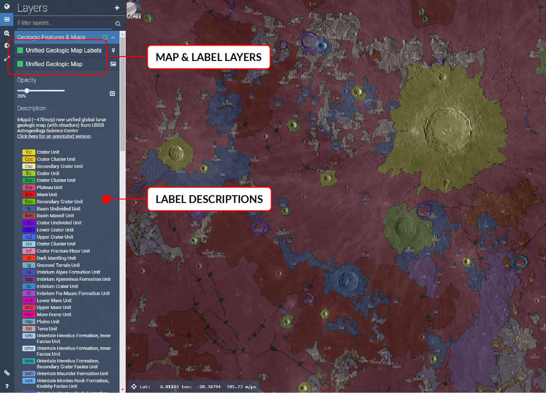
The new Unified Geologic Map and corresponding labels layers from the USGS Astrogeology Science Center released earlier this year is another amazing addition to Lunar QuickMap. This new geologic map allows the comparison of geologic units across the Moon with unified unit descriptions and ages for all areas. It unifies all the previous Wilhelms geologic maps that were previously on QuickMap, ensuring units match up and are consistent across the entire Moon. In addition, various contacts and linear features will now be displayed and contact labels may be displayed as an overlay on the map (Figure 1).
New LOLA Sun and Earth visibility layers are also now available for the Orthographic (South Pole) and Orthographic (North Pole) projections. With new missions to land at the lunar poles being planned, these layers allow planning future mission communications with Earth (Average Earth Visibility) and solar availability for a given area (Average Sun Visibility), which helps plan for charging solar-powered equipment. The Sun visibility also helps to understand the thermal environment at lander scales for volatile retention and thermal breakdown effects.
A combination of Lunar Prospector and Kaguya magnetic anomaly maps at the surface and at 30 km are also now available (Figure 2). These Lunar Prospector/Kaguya Magnetic anomaly maps are currently the most complete and highest resolution magnetic anomaly maps for the Moon. These should be useful resources for anyone studying features related to these anomalies, such as lunar swirls.
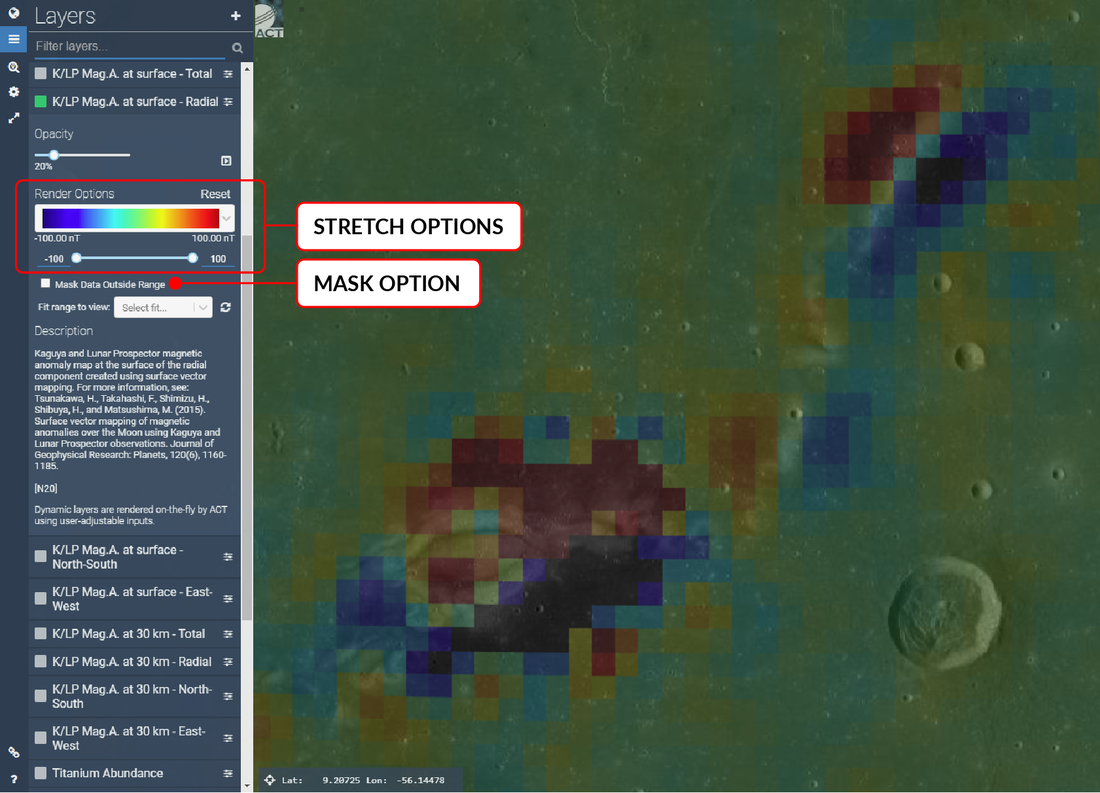
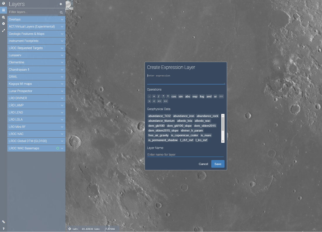
The new layers available in Lunar QuickMap is almost as exciting as the new improvements to support increased layer customization. Dynamic layers is one of these exciting features. With dynamic layers, users may now stretch layer data and mask data outside a desired range using over 40 dynamic layers. Combine these layers with the added ability to create custom layers from over 20 datasets using algebraic expressions (Figure 3), and these new updates transform QuickMap into a powerful platform for data visualization and analysis by giving users unprecedented access to the geophysical data.
Users can now explore the variability of data sets over small regions by dynamically adjusting the scale bars, compare datasets with similar information (slope from the SLDEM vs. GLD100), and filter out data to facilitate interpretation (i.e. removing areas correlated with high slopes from the LOLA albedo map to better understand where there might be surface frost near the poles).
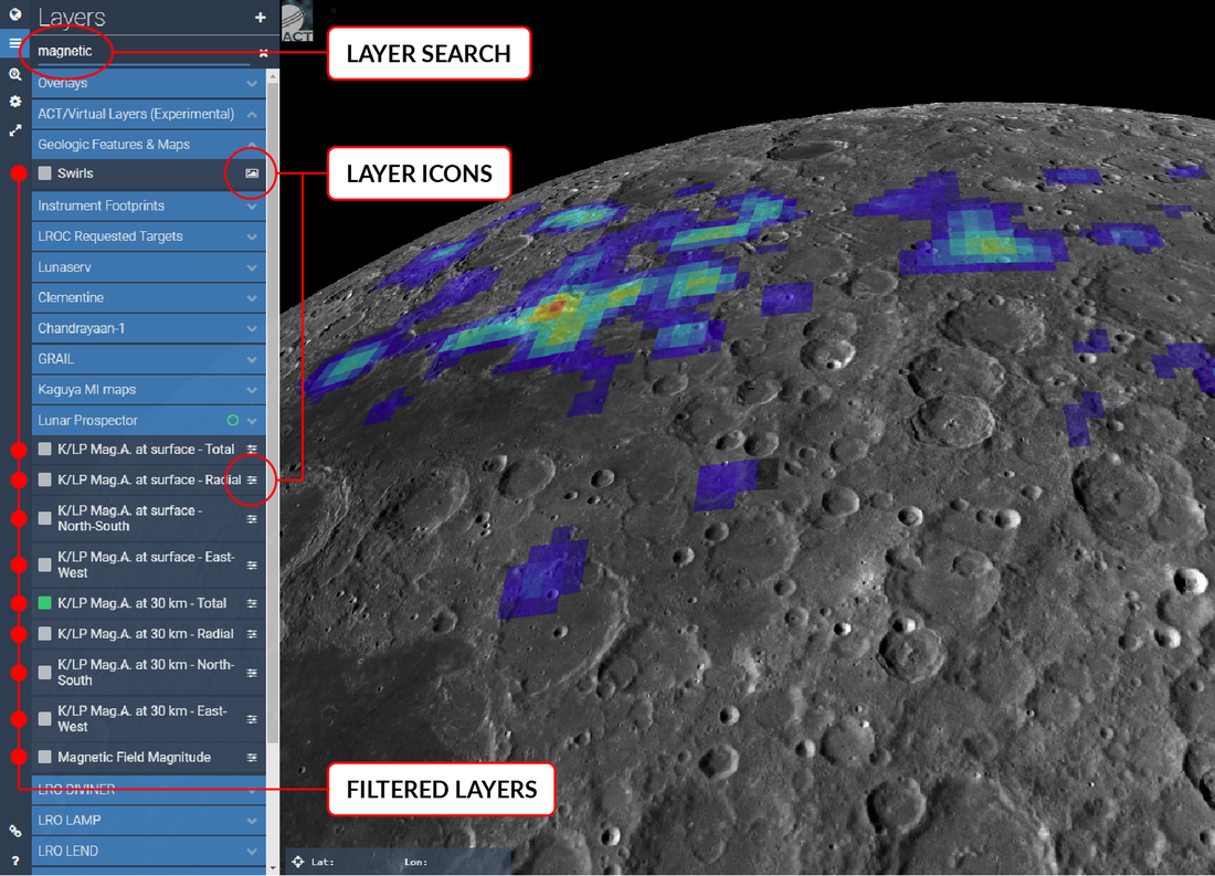
The new features expand on the already breathtaking amount of lunar data and viewing options available to users, so in order to help find and explore that data, QuickMap navigation has also been made more efficient with updates like a new layer search to help filter layers, existing search and filter improvements, and new layer icons to help identify layers by type (Figure 4).
Short URLs are another feature that has been improved to provide shortened, parameter-rich URLs for sharing customized Lunar QuickMap views with friends and colleagues. We've supplied a handful of examples and descriptions (Table 1) to help demonstrate a variety of shareable options.
Table 1. Short URL examples.
| Short URL | Example | Layers | Option |
|---|---|---|---|
| https://bit.ly/2S4QDkW | Show current LROC satellite track | LRO Satellite | Fly around point |
| https://bit.ly/2ZtOcwa | Custom algebraic exp: (albedo_wac/albedo_lola) | Virtual, Nomenclature | Fly around point |
| https://bit.ly/2So6gmu | Custom algebraic exp: abs(dem_gld100 - dem_sldem2015) | Virtual, Basemap | Mask 30-200 m |
| https://bit.ly/2tNFgV0 | Temporal layer (time dynamic layer) | Shaded Relief | |
| https://bit.ly/2uq9DRt | Custom slope rendering | SLDEM2015 (+LOLA) | Mask >16.6° |
Another example of a short URL (https://bit.ly/3awqbbb) shows how a user might share exploration concepts by combining some of the new updated features, layers, and the Draw/Search tools: Ideal search site based on terrain slope <15° and permanent shadow; Favorable base location with good polar illumination and low terrain slope; Possible ground track with elevation along a drawn path; Flicker mode enabled on the LRO LEND Polar Water Equivalent Hydrogen layer; WAC Mosaic + NACs basemap; Orthographic (South Pole) projection.
Short URLs are a handy way of exporting and saving custom views from Lunar QuickMap, but users may also enter parameters into the URL for even further custom visualizations. In addition to using SPICE, users may now load derived LRO Keplerian parameters. For example, we can add an orbit using a format-strict input: x,y,z,vx,vy,vz. For example:
https://quickmap.lroc.asu.edu/layers?sat=1926.33304,124.15909,-146.93061,0.12725,-0.00692,1.58686
The new Lunar QuickMap update includes some great new layers and features that further enhance user customization and exploration when it comes to lunar data and the Moon. LROC is excited to share these updates, and we hope you enjoy getting a closer look at our favorite neighbor. If you still have questions about the new features, please watch the following video, or take a look at the resources linked below, which contain detailed information about the newly released updates.
For more examples, please see the LROC Lunar QuickMap examples page. For a detailed list of updates, take a look at the Lunar QuickMap 2020 Update document. Check back often for future Lunar QuickMap updates and visit our regularly updated and popular LROC Featured Image releases.
Additional links:
Lunar QuickMap
Lunar QuickMap Layer Inventory
QuickMap online guide
Published by Rick Hoppe on 1 June 2020