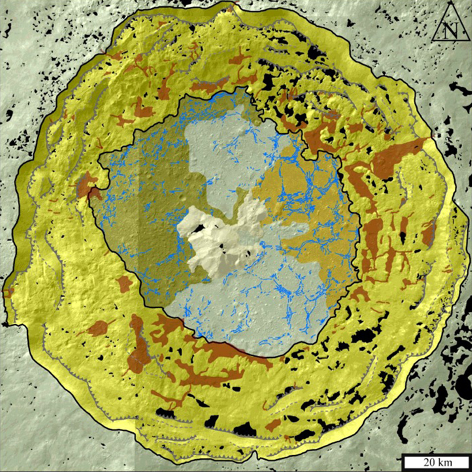
Geological maps are made as a tool for understanding and interpreting the formation and modification of rocks exposed at the surface of the Earth, other terrestrial planets, asteroids, and/or moons. The construction of geological maps on the Earth typically involves going into the field to make direct observations and measurements of the rocks of interest. For cases where the field area is difficult to access, remote sensing data is used as the basis for making the maps. In the case of the Moon or other planetary surfaces, geologists usually do not have rock samples that can be directly tied to specific geologic units, so they draw boundaries between different units using the appearance or morphology of the different materials. The result is a geomorphological map, from which scientists make geologic interpretations.

Tycho crater is one of the most visible and important craters on the Moon due to its extensive, bright ray system. It appears in early geological maps of the Moon, for example in the map of the lunar nearside by Wilhelms and McCauley (1971), as well as a more detailed map of the Tycho area by Pohn [1972]. The latter used Lunar Orbiter V photographs, with a resolution of around 100 m, to define 14 different units in and around Tycho. Based on the same photographs, a detailed map of the distribution of impact melt around Tycho was also published by Morris et al. [2000]. The new geomorphological map (above) shows the interior of the crater in more detail than ever before. A higher resolution map of the impact melt deposits (below) in and around the crater was also made.
Tycho crater is thought to have formed from an impactor that hit the surface at an angle, arriving from the southwest. The distribution of impact melt around Tycho crater supports this interpretation, as there are fewer pools of impact melt to the southwest, and many to the northeast (see image below), which would have been downrange of the impact trajectory. After it was ejected from the crater, impact melt accumulated into larger pools in areas where preexisting craters made sinks that could easily trap the melt (see ‘a’ image below), or where preexisting crater rims prevented melt from travelling farther from Tycho crater (see ‘b’ on image below).

Maps such as these shape our understanding of how we can use impact crater deposits to learn about the cratering process. No humans witnessed the impact event that created Tycho crater some 100 million years ago, but we can use the deposits it left behind to recreate how it happened. Read the full story of how this new map of Tycho crater was created and the insights it has provided into the formation of the crater:
Krüger T., C. H. van der Bogert, and H. Hiesinger (2016). Geomorphologic mapping of the lunar crater Tycho and its impact melt deposits, Icarus, 273, 164–181, doi:10.1016/j.icarus.2016.02.018.
Explore one of the LROC NAC images (M106935800R, image width approximately 3 km) used to investigate the geomorphology of impact crater deposits at Tycho crater in full resolution below!
Related LROC Feature Image Posts:
Tycho Central Peak Spectacular!
Polygonal Fractures on Tycho ejecta
Published by Brett Denevi on 15 June 2016