Pits Atlas: Copernicus 7
| Impact Melt pit: Copernicus | |
|---|---|
| Name | Copernicus 7 |
| Lat. | 10.0763 |
| Long. | 340.0269 |
| Desc. | Round pit in a linear, round-bottomed 37m-wide depression. This depression has some very shallow cliffs at the rim in most places, and runs >300m NW, and terminates in a ~70m wide round-bottomed depression ~150m SE. The pit is in the middle of a set of collapses, and the central pit is only visible in the highest-Sun images (the floor is never visible). There is a tiny depression, with a bit of shadow visible at even 11 degrees incidence, 18m NE (outside the linear depression). There is a rounded mound (ooze dome?) ~180m NE. |
| Types | |
| Terrain | Impact Melt |
| Host Feature | Copernicus |
| Funnel Min. Diam. | 24 |
| Funnel Max. Diam. | 26 |
| Inner Min. Diam. | 4 |
| Inner Max. Diam. | 6 |
| Azimuth | 45 |
| Depth | >21.0 |
| Depth 1 | >21.0 |
| Depth 2 | >19.0 |
| Depth 3 | >20.0 |
| Best Stereo Left | M144755352L |
| Best Stereo Right | M144755352L |
| DTMs | |
| Clipping Width | 200 |
| Other IMGs | M168333206R |
| Data Warning | All depths are from very high Sun |
| Entrance Ramp | N |
| Overhang | ? |
| Nearby Pits? | Y? |
| Nearby Fractures? | N |
| Nearby Depressions? | Y |
| In Dome | N |
| Beside Dome | N |
| In Depression | Y |
| Colinear Pits | N |
| Colinear Depressions | N |
| Colinear Fractures | N |
| Copernicus 7 Shaded Relief | |
|---|---|
 |
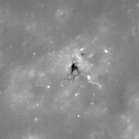
| M1103695396L | |
|---|---|
 |
|
| Line | 22972 |
| Sample | 3165 |
| Inc. Angle | 17.25 |
| Emission Angle | -1.38 |
| Time | 11.13 |
| Resolution | 1.21 |
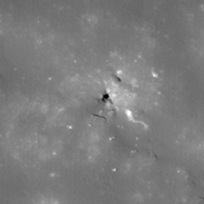
| M1177898186R | |
|---|---|
 |
|
| Inc. Angle | -16.18 |
| Emission Angle | -0.24 |
| Time | 12.91 |
| Resolution | 1.17 |
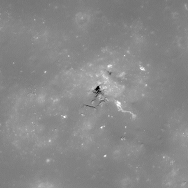
| M109365462L | |
|---|---|
 |
|
| Inc. Angle | 11.9 |
| Emission Angle | -1.98 |
| Time | 11.82 |
| Resolution | 0.52 |
| Copernicus 7 Stereo |
|---|
 |