Pits Atlas: Fraunhofer G 1
| Impact Melt pit: Fraunhofer G | |
|---|---|
| Name | Fraunhofer G 1 |
| Lat. | -38.5001 |
| Long. | 58.3638 |
| Desc. | Rectangular pit near a possible melt flow edge. There are several other depressions/collapses in the area: a ~7m deep collapse with vertical northern wall (other edges are shallow slopes) ~25m S, and shallow collapses with some degree of rim ~75m W and ~200m E. This pit has no entrance ramps, and the floor appears smooth. |
| Types | |
| Terrain | Impact Melt |
| Host Feature | Fraunhofer G |
| Funnel Min. Diam. | 14 |
| Funnel Max. Diam. | 23 |
| Inner Min. Diam. | 11 |
| Inner Max. Diam. | 17 |
| Azimuth | 25 |
| Depth | 4.0 |
| Depth 1 | 4.0 |
| Depth 2 | 4.9 |
| Depth 3 | >6.0 |
| Best Stereo Left | M185497131L |
| Best Stereo Right | M185497131L |
| DTMs | |
| Clipping Width | 200 |
| Other IMGs | |
| Data Warning | Depth 3 is from W rim, other depths are from W. |
| Entrance Ramp | N |
| Overhang | ? |
| Nearby Pits? | Y |
| Nearby Fractures? | N |
| Nearby Depressions? | Y |
| In Dome | Y |
| Beside Dome | N |
| In Depression | N |
| Colinear Pits | Y |
| Colinear Depressions | N |
| Colinear Fractures | N |
| Fraunhofer G 1 Shaded Relief | |
|---|---|
 |
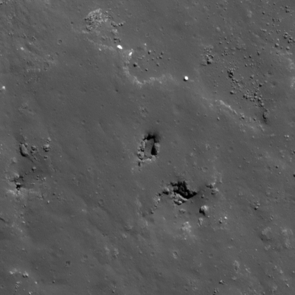
| M126547168L | |
|---|---|
 |
|
| Line | 26253 |
| Sample | 4366 |
| Inc. Angle | 45.51 |
| Emission Angle | -0.62 |
| Time | 10.42 |
| Resolution | 0.39 |
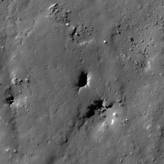
| M1162092747L | |
|---|---|
 |
|
| Inc. Angle | -43.18 |
| Emission Angle | 1.25 |
| Time | 13.61 |
| Resolution | 0.8 |
| M1175012025L | |
|---|---|
 |
|
| Inc. Angle | -58.19 |
| Emission Angle | 1.79 |
| Time | 15.06 |
| Resolution | 0.6 |
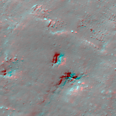
| Fraunhofer G 1 Stereo |
|---|
 |