Objectives
Extended Mission
LRO is currently in an Extended Mission phase, focused on collecting data needed to address key lunar science questions, including:
1. Chronology / Bombardment
Determine bombardment history of the Moon, from the timing of basin-forming events down to small, recent impact events. Measure lunar landforms at 0.5–2.0 meter pixel scales for more than 10,000 targeted sites, and measure mineralogical variation of the Moon via ultraviolet-visible observations at sub-kilometer pixel scales over at least 75% of the surface.
2. Crustal Evolution
Investigate geological processes and their role in the evolution of the lunar crust and shallow lithosphere. This investigation includes imaging of landforms at ~100 meter scale, down to ~1 meter scale, for thousands of targeted regions. Obtain oblique (more than 60° emission angle) imaging of key science targets for the purpose of assessing stratigraphy, at 2 meter pixel scales for an average of at least two targeted regions per month. Also, obtain UV/Visible (400 to 100 meter pixel scales) multi-phase angle imaging over at least 90% of the lunar surface and measure mineralogical variations of the Moon via ultraviolet-visible observations at sub-km pixel scale over a minimum of 75% of the lunar surface.
3. Regolith Evolution
Look for evidence of processes that shaped the global lunar regolith as they relate to evolution of the crust, verifying physical characteristics of the upper-most regolith layers via their textures, scattering mechanisms and composition. Measure the surface morphology at 0.5–2.0 meter scales, and other physical properties at meter pixel scale for specific targets.
4. Polar Volatiles
Investigate volatile sources, sinks and transfer mechanisms with emphasis on the lunar polar regions, including permanently shadowed regions (PSRs). Measure polar region landforms in PSRs at better than 20 meter horizontal scales. Also, measure reflectivity as a function of phase angle at meter and 100 meter scales near PSRs within 10° of each pole.
Primary Mission
LROC was originally designed to achieve the following measurement objectives:
1. Find potential landing sites
LROC provides images of meter-scale and smaller features that pose a potential threat to landing and obstacles to the trafficability of future human and robotic explorers. LROC is capable of accurately assessing lunar surface characteristics due its 0.5 m/pixel high-resolution images. In addition, when the Sun is <30° above the horizon, features less than 0.5 m high can be detected by their long shadows.
2. Map regions of permanent shadow or illumination
The low angle spin axis of the Moon (only 1.5°, compared with the Earth's 28.5°), potentially leaves some areas near the poles in permanent shadow while allowing others areas to remain in permanent or near-permanent illumination. Areas of permanent or near-permanent illumination are prime locations for future lunar outposts due to benign thermal conditions and constant solar-power. Additionally, theory, radar data, and neutron measurements suggest that ice may be present in the permanently shadowed regions (any water-bearing materials are a potential resource for future lunar explorers). During each orbit around the Moon, the WAC acquires images of the polar regions (90° to 90° north and south latitude) at a scale of tens to hundreds of meters per pixel to map the extents of permanent shadow and illumination.
3. Create high-resolution maps of polar massifs with permanent or near-permanent illumination
During lunar summers, the NACs take images of both polar regions (above 85.5° latitude) when shadows are minimal. These images are then compiled into mosaics of each pole, sampled to 1 meter/pixel. These high-resolution mosaics provide a basemap for future polar exploration.
4. Observe regions from multiple angles to derive high-resolution topography
LROC acquires images of regions of scientific interest from multiple angles. These images can be analyzed using stereogrammetric and photometric methods to create precise, high-resolution topographic maps.
5. Improve maps of mineralogical components of the lunar crust
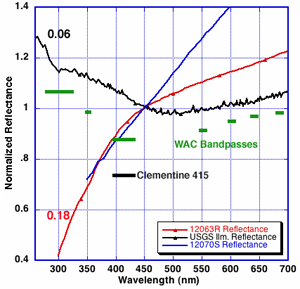
The WAC will collect global multispectral observations in seven wavelengths, which will be used to characterize lunar resources. Of particular interest is the abundance and distribution of the mineral ilmenite, an excellent source of oxygen, titanium metal, and solar-wind-implanted volatiles, such as hydrogen and helium. These volatile elements may facilitate the creation of water and possibly fuels.
6. Create a global morphology base map
By mapping the lunar surface at large solar incidence angles (>50°), LROC creates high-precision morphologic maps, which are crucial for systematic geologic mapping and crater counting. The crater density for a given region is highly correlated with its age, thus, morphologic maps can be used to infer the age of a region.
7. Characterize the regolith
LROC NAC high-resolution images give scientists extremely detailed views of the regolith (lunar soil). Depending on regolith thickness, different sizes of craters have distinctive interior shapes. Mapping the frequency and distribution of these crater morphologies provides accurate estimates of regolith thickness around potential lunar landing sites.
8. Determine impact hazards
By comparing LROC NAC images with very young mare surfaces and Apollo 15–17 panoramic images, the rate at which meteors are currently impacting the lunar surface can be determined. With this information, the kind and frequency of impacts that future lunar structures will need to withstand can be determined.