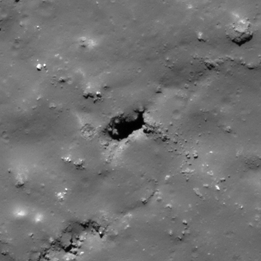
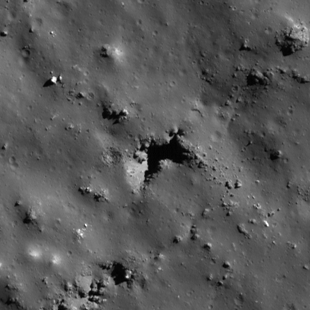
Pits Atlas: Tycho 12
| Impact Melt pit: Tycho | |
|---|---|
| Name | Tycho 12 |
| Lat. | -43.2169 |
| Long. | 349.5787 |
| Desc. | Crescent-shaped pit. SW wall is ramp from rim to [lost in shadow], other walls appear vertical. ~65m ENE of, and slightly out of line with, the N end of a NE-SW-trending perfectly straight sharp-bottomed depression- there are a couple other depressions paralleling it at 1-200m spacing. Some large collapses nearby, and a probable ooze dome two linear depressions (~250m) to the SE. |
| Types | |
| Terrain | Impact Melt |
| Host Feature | Tycho |
| Funnel Min. Diam. | 31 |
| Funnel Max. Diam. | 47 |
| Inner Min. Diam. | 16 |
| Inner Max. Diam. | 34 |
| Azimuth | 50 |
| Depth | 15.0 |
| Depth 1 | 13.1 |
| Depth 2 | 16.8 |
| Depth 3 | 16.0 |
| Best Stereo Left | M1177818994L |
| Best Stereo Right | M1177818994L |
| DTMs | |
| Clipping Width | 200 |
| Other IMGs | |
| Data Warning | Depths are from varied points on the rim, which are at varied heights. |
| Entrance Ramp | Y |
| Overhang | ? |
| Nearby Pits? | N |
| Nearby Fractures? | N? |
| Nearby Depressions? | Y |
| In Dome | N |
| Beside Dome | N |
| In Depression | N |
| Colinear Pits | N |
| Colinear Depressions | Y |
| Colinear Fractures | N |
| Tycho 12 Shaded Relief | |
|---|---|
 |
| M157661677L | |
|---|---|
 |
|
| Line | 2079 |
| Sample | 1170 |
| Inc. Angle | 48.87 |
| Emission Angle | -2.49 |
| Time | 10.5 |
| Resolution | 0.47 |
| M139973084L | |
|---|---|
 |
|
| Inc. Angle | -41.92 |
| Emission Angle | 2.95 |
| Time | 12.36 |
| Resolution | 0.51 |
| M175348372L | |
|---|---|
 |
|
| Inc. Angle | 57.38 |
| Emission Angle | -1.53 |
| Time | 9.11 |
| Resolution | 0.34 |
| Tycho 12 Stereo |
|---|
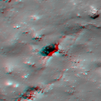 |