Pits Atlas: Aristarchus 2a
| Impact Melt pit: Aristarchus | |
|---|---|
| Name | Aristarchus 2a |
| Lat. | 23.873 |
| Long. | 312.3029 |
| Desc. | Westernmost of a chain of three pits trending E-W. West wall appears collapsed, other walls are vertical, though south wall looks a bit shorter. Visible funnel. |
| Types | |
| Terrain | Impact Melt |
| Host Feature | Aristarchus |
| Funnel Min. Diam. | 18 |
| Funnel Max. Diam. | 22 |
| Inner Min. Diam. | 16 |
| Inner Max. Diam. | 19 |
| Azimuth | 35 |
| Depth | 5.0 |
| Depth 1 | 5.6 |
| Depth 2 | 4.5 |
| Depth 3 | 5.2 |
| Best Stereo Left | M1129801944L |
| Best Stereo Right | M1129801944L |
| DTMs | |
| Clipping Width | 200 |
| Other IMGs | |
| Data Warning | Depths 2 and 3 are from the south wall, depth 1 is from east wall |
| Entrance Ramp | Y |
| Overhang | ? |
| Nearby Pits? | Y |
| Nearby Fractures? | N |
| Nearby Depressions? | Y |
| In Dome | N |
| Beside Dome | N |
| In Depression | N |
| Colinear Pits | Y |
| Colinear Depressions | N |
| Colinear Fractures | N |
| Aristarchus 2a Shaded Relief | |
|---|---|
 |
| M109548636R | |
|---|---|
 |
|
| Line | 4107 |
| Sample | 3230 |
| Inc. Angle | 25.79 |
| Emission Angle | 1.57 |
| Time | 11.69 |
| Resolution | 0.52 |
| M1193372314R | |
|---|---|
 |
|
| Inc. Angle | -27.32 |
| Emission Angle | 0.14 |
| Time | 12.75 |
| Resolution | 1.08 |
| M1129794833R | |
|---|---|
 |
|
| Inc. Angle | -46.82 |
| Emission Angle | -1.73 |
| Time | 14.7 |
| Resolution | 1.28 |
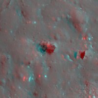
| Aristarchus 2a Stereo |
|---|
 |