Pits Atlas: Sharonov 1a
| Impact Melt pit: Sharonov | |
|---|---|
| Name | Sharonov 1a |
| Lat. | 12.5745 |
| Long. | 173.4036 |
| Desc. | Small pit with no apparent wall collapses, and probably no floor visible. Located on top of what appears to be a wrinkle ridge. ~75m further NW along the ridge is a cluster of depressions/pit/collapses, including Sharonov 1b. |
| Types | |
| Terrain | Impact Melt |
| Host Feature | Sharonov |
| Funnel Min. Diam. | 13 |
| Funnel Max. Diam. | 19 |
| Inner Min. Diam. | 6 |
| Inner Max. Diam. | 7 |
| Azimuth | 20 |
| Depth | >12.0 |
| Depth 1 | 21.0 |
| Depth 2 | >13.0 |
| Depth 3 | >10.0 |
| Best Stereo Left | M1107145968R |
| Best Stereo Right | M1107145968R |
| DTMs | |
| Clipping Width | 200 |
| Other IMGs | |
| Data Warning | Depth 1 may be high, due to combinations of high Sun and low resolution. All measurements may be affecteed by low resolutions. |
| Entrance Ramp | N |
| Overhang | ? |
| Nearby Pits? | Y |
| Nearby Fractures? | N |
| Nearby Depressions? | Y |
| In Dome | Y |
| Beside Dome | N |
| In Depression | N |
| Colinear Pits | Y |
| Colinear Depressions | N |
| Colinear Fractures | N |
| Sharonov 1a Shaded Relief | |
|---|---|
 |
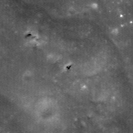
| M1148378060R | |
|---|---|
 |
|
| Line | 12903 |
| Sample | 747 |
| Inc. Angle | -11.53 |
| Emission Angle | -0.15 |
| Time | 12.09 |
| Resolution | 1.3 |
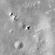
| M154100698R | |
|---|---|
 |
|
| Inc. Angle | -21.97 |
| Emission Angle | -0.52 |
| Time | 13.28 |
| Resolution | 0.58 |
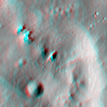
| M1150734112L | |
|---|---|
 |
|
| Inc. Angle | 28.91 |
| Emission Angle | -1.67 |
| Time | 10.23 |
| Resolution | 1.31 |
| Sharonov 1a Stereo |
|---|
 |