The Gravity Recovery and Interior Laboratory (GRAIL) spacecraft are nearing the end of their mission. Launched in September of 2011, these two intrepid spacecraft have mapped the lunar gravity field in unprecedented detail, a boon for lunar scientists! However, they have expended their fuel reserves, and both will make controlled crashes onto the lunar surface today.
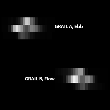
During their one year mission the GRAIL spacecraft often came close to LRO, in some cases the distance was less than 10 km! On 7 October 2012 as GRAIL A passed within 11 km, LRO pitched forward 30° and and rolled 16° to snap an image as the Sun glinted off Ebb's solar panels and main deck. The next day a similar opportunity presented itself and LROC imaged GRAIL B.

In both instances the orbit track of the GRAIL spacecraft was angled by 120° relative to LRO's orbit, and the twin spacecraft passed below LRO in the lunar night. Since the LROC NAC is a line scanner, it builds up an image line-by-line, and depends on the spacecraft to orient its CCD sensor perpendicular to the ground path. In the case of the GRAIL images, LRO was not reoriented so the images are distorted, the slews added to the distortion. Using spacecraft ephemeris, the distorted image of GRAIL was corrected back to a normal geometry.

Ebb and Flow will impact a 2400 meter (7874 feet) tall mountain, about 450 km from the lunar north pole, at approximately 2:28 PM PST, Monday 17 December 2012. Antennas on Earth will be tracking both spacecraft until the moments of impact. The last few orbits will be very low, and may provide some extremely high resolution gravity profiles. Just before impact, the two spacecraft will come astonishingly close to a ridge between 71°N and 72°N (see WAC mosaic below).

The two GRAIL spacecraft are identical, and each has a mass (without fuel) of about 130 kg (287 lbs). When they hit the mountain at about 1.6 km/sec (3579 mph), they will each make small impact craters, about a meter across. The craters will be too small to resolve with LROC, but the bright ejecta around those craters, which should be a few meters across, might be visible. Optimal lighting for future LROC imaging of the GRAIL craters will occur next March through April (2013).
Published by Mark Robinson on 17 December 2012